From Pilings to Boathouses: Navigating Lowcountry Marine Construction
Why Lowcountry Waterfront Construction Demands a Specialized Approach
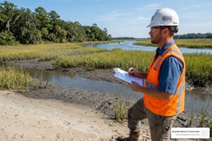
Lowcountry waterfront construction is one of the most complex and regulated forms of building in South Carolina — and getting it right requires local expertise, careful planning, and a deep understanding of tidal environments.
If you’re looking for a quick overview of what’s involved, here’s what you need to know:
Key facts for waterfront property owners in coastal South Carolina:
- Permits are required from SCDES Bureau of Coastal Management (BCM) and, in some cases, the US Army Corps of Engineers (USACE)
- Dock size is determined by creek width — ranging from 120 sq ft (20-50 ft wide creeks) up to 600 sq ft (over 150 ft wide)
- Private residential permits typically take around 120 days and are valid for 5 years
- Licensed marine contractors are legally required for projects over $5,000
- Elevated foundations (piles, piers, reinforced concrete) are standard due to flood zones and tidal influence
- Materials must resist salt air, moisture, wind, and tidal scour — stainless fasteners and corrosion-resistant finishes are baseline requirements, not upgrades
The Lowcountry’s marshes, tidal creeks, and waterways are breathtaking. But building near them is fundamentally different from standard construction.
Soil composition can shift within a single parcel. Groundwater rises and falls daily with the tides. Many properties sit inside designated flood zones. And the regulatory framework — spanning local zoning, state coastal law, and federal environmental acts — adds layers of complexity that can trip up even experienced builders.
At the same time, the region is in the middle of a major transformation. Landmark projects like the 70-acre Union Pier redevelopment, the 189-acre Magnolia site along the Ashley River, and the Navy Yard Charleston are reshaping what waterfront development looks like in this region — blending public access, maritime heritage, and resilient design at a scale that hasn’t been seen here before.
Whether you’re building a private dock on James Island or navigating the permitting process for a seawall on Kiawah, the stakes are high and the margin for error is low.
This guide breaks down everything you need to know — from dock eligibility rules and permit timelines to foundation engineering and material selection — so you can make informed decisions about your waterfront project.
, permit types (General vs. Individual), dock size rules by creek width (under 20ft no dock, 20-50ft 120 sq ft, 51-150ft 160 sq ft, over 150ft 600 sq ft), key construction elements (piles, bulkheads, floating docks, boat lifts), material choices (pressure-treated lumber, composite, GFRP, vinyl), and environmental factors (flood zones, tidal influence, manatee protection, erosion control), arranged in a clear flowchart style with the Ashley River as background - lowcountry waterfront construction infographic")
Transformative Redevelopment: The Future of Lowcountry Waterfront Construction
The Charleston skyline and its relationship with the water are undergoing a generational shift. We are seeing a move away from industrial, closed-off port facilities toward vibrant, mixed-use districts that prioritize the public’s connection to the harbor and rivers.
Several massive projects are currently redefining lowcountry waterfront construction:
- Union Pier: This roughly 70-acre site (including 7 acres of wetlands and 20 acres of existing docks) is transitioning from a cargo and cruise terminal into a world-class waterfront district. The new Urban Waterfront Future Land Use District guides this evolution, ensuring the site features resilient development, public parks, and housing that respects Charleston’s historic scale.
- Laurel Island: A 196-acre project (formerly a landfill) planned for over 4,000 housing units, 39 acres of public park, and millions of square feet of office and retail space.
- Magnolia Landing: Spanning 192 acres along 1.5 miles of the Ashley River, this district blends urban vibrancy with the natural rhythms of the marsh.
- Navy Yard Charleston: An 85-acre redevelopment of the historic naval base, aiming to create 3.5 million square feet of mixed-use space.
- Battery Park: A 70-acre master-planned community designed for high-density residential living with immediate water access.
For those interested in how these large-scale visions translate into functional infrastructure, you can explore more info about commercial marine services to see the engineering required for such massive undertakings.

Activating the Public Realm at Waterfront Park
Success in waterfront activation isn’t just about new buildings; it’s about the spaces between them. The iconic Charleston Waterfront Park serves as the gold standard. Designed with involvement from firms like Sasaki, this 7-acre park transformed obsolete Cooper River port facilities into a landmark public space.
One of its most impressive feats was withstanding the full force of Hurricane Hugo just before its 1990 opening. This proved that high-quality marine engineering—incorporating view corridors, continuous public access, and the famous pineapple fountain—can be both beautiful and incredibly storm-resilient.
Environmental Remediation and Site Transformation
Many of today’s most desirable waterfront spots were once industrial “brownfields.” The Magnolia site, for instance, required extensive Superfund cleanup to address a century of arsenic and lead contamination. Today, led by Highland Resources, the 189-acre site (including 49 acres of marsh) is being restored. These 20-to-30-year build-outs represent a massive investment—estimated at $2 billion for Magnolia alone—in turning contaminated land back into healthy, accessible marshland and neighborhoods.
Navigating the Regulatory Landscape and Permitting Process
If you want to drive a single piling into the pluff mud, you’re going to need a permit. In South Carolina, the “Critical Area” (coastal waters, tidelands, and beach systems) is overseen primarily by the SCDES Bureau of Coastal Management (BCM).
For larger projects or those affecting federal channels (like the Intracoastal Waterway), the US Army Corps of Engineers (USACE) also gets involved. Most applications are now handled through the ePermitting portal, which streamlines the process for Critical Area permits.
| Feature | General Permit (GP) | Individual Permit (IP) |
|---|---|---|
| Scope | Minor activities (standard docks, repairs) | Major projects (marinas, large dredging) |
| Timeline | Typically faster (approx. 120 days) | Longer, involves deeper review |
| Fee | Lower (e.g., $50 administrative fee) | Higher, based on project scale |
| Public Notice | Often limited to neighbors | Broad public comment period |
Understanding Dock Eligibility and Dock Master Plans (DMPs)
Before you buy a waterfront lot, you must check its dock eligibility. Many newer subdivisions have a Dock Master Plan (DMP) on file with the state. A DMP pre-determines which lots can have docks, where they should be placed, and whether they must be “joint-use” (shared with a neighbor).
SCDES BCM regulations require specific parcel frontage—usually a minimum of 75 to 100 feet—for a private dock. If your creek is less than 20 feet wide, you generally cannot build a dock unless you have 500 feet of frontage, and even then, the structure is capped at a tiny 50 square feet. Once construction is finished, an “as-built” survey must be submitted to ensure the structure matches the approved plans exactly.
Regulatory Standards for Boat Storage and Lifts
Boat lifts are a staple of the Lowcountry lifestyle, but they are strictly regulated to prevent “walling off” the marsh. Standard rules include:
- Lifting Capacity: Must be matched to the boat’s wet weight (fuel, gear, and engines).
- Pile Spread: A 12’x12′ pile spread is common for 12,000-pound lifts.
- Size Limits: Boatlifts are generally restricted to 160 square feet.
- Roofs: If you add a cover, it must be open-sided. Gabled roofs are capped at 15 feet high, while monosloped roofs are limited to 12 feet from the pier flooring.
For homeowners looking to protect their investment while staying compliant, more info about residential marine services can provide clarity on these technical specs.
Engineering for Resilience: Foundations and Environmental Factors
Building on the water is a battle against physics. Between the daily 5-to-7-foot tidal swings and the threat of hurricane-force storm surges, your foundation is everything.
Technical Standards for Lowcountry Waterfront Construction
We use geotechnical testing to understand soil bearing capacity. In the Lowcountry, “soft” soils often require driving piles deep into the substrate until they hit a load-bearing layer.
Modern lowcountry waterfront construction is also seeing a shift in materials. For projects like the Low Battery Seawall, the city utilized Glass Fiber Reinforced Polymer (GFRP) instead of traditional steel rebar. GFRP doesn’t rust, making it ideal for the high-salinity environment of Charleston Harbor. For residential docks, we prioritize stainless steel fasteners and impact-rated structures to ensure the dock stays put when the wind picks up.
Erosion Control and Shoreline Stabilization
If you’re losing your backyard to the tide, you need stabilization.
- Bulkheads: Vertical walls made of vinyl, wood, or concrete. Vinyl is popular for its 50-year lifespan and resistance to wood-boring marine organisms.
- Seawalls: Heavier structures designed to withstand direct wave action.
- Rip-Rap: Strategically placed stones that absorb wave energy.
Effective stabilization requires a “tie-back” system—anchors driven deep into the land to keep the wall from leaning. And don’t forget hurricane preparedness for boat lifts; during a storm, the goal is to get the boat as high as possible and secure it to prevent it from becoming a floating battering ram.
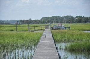
Essential Components of Lowcountry Marine Construction
A functional waterfront setup is more than just a walkway. It’s a system of components designed to move with the environment.
- Fixed Piers: The elevated walkway that gets you across the marsh.
- Floating Docks: These rise and fall with the tide, providing a consistent platform for boarding.
- Ramps/Gangways: The connection between the fixed pier and the floating dock.
- Mooring Piles and Dolphins: Independent pilings used to secure larger vessels.
Recent public projects, like the Riverland Terrace Boat Landing project, demonstrate the complexity of these structures, often requiring concrete “groundout pads” to protect the riverbed from heavy use.
Material Selection for Harsh Coastal Environments
The salt-laden air in Charleston is incredibly corrosive. We recommend:
- Pressure-Treated Lumber: Must be treated to “marine grade” retention levels (0.60 or 2.5 pcf depending on use) to survive underwater.
- Composite Decking: Resists rot and splinters, though it requires sturdy framing.
- Marine-Grade Aluminum: Lightweight and naturally corrosion-resistant for ramps.
- Cathodic Protection: Using “sacrificial anodes” on metal components to prevent electrolysis and rust.
Frequently Asked Questions about Lowcountry Waterfront Construction
How does creek width determine my dock size?
SCDES BCM uses “marsh-to-marsh” vegetation measurements to determine creek width.
- Creeks 20-50ft wide: Max dock size is 120 sq ft.
- Creeks 51-150ft wide: Max dock size is 160 sq ft.
- Creeks >150ft wide: Max dock size is 600 sq ft.
- Under 20ft: Generally no dock allowed without significant frontage (500ft).
What are the typical costs and timelines for a permit?
The average timeline for a private residential dock permit is about 120 days. This includes a 15-to-30-day public comment period. Permits are valid for 5 years. Costs include non-refundable administrative fees (starting around $50 for general permits) plus the cost of a professional survey by a licensed SC surveyor.
Why is local expertise vital for Lowcountry waterfront construction?
Local builders understand the “unwritten” rules of the pluff mud. We know how to navigate manatee protection protocols (required from May to November) and what to do if you encounter archaeological remains (common in historic Charleston). Most importantly, we ensure your project is built by a licensed marine contractor, which is legally required for any work over $5,000.
Conclusion
Building on the water in Charleston, Johns Island, and the surrounding Lowcountry is about more than just aesthetics—it’s about coastal stewardship and preserving our maritime heritage. A well-constructed dock or seawall doesn’t just provide recreation; it protects your shoreline and adds significant long-term value to your property.
At Blutide Marine, we specialize in tailored building adapted to these unique waterfront challenges. We understand the tides, the regulations, and the engineering required to make your vision a reality.
Start your Lowcountry waterfront project today and let us help you navigate the journey from pilings to boathouses.